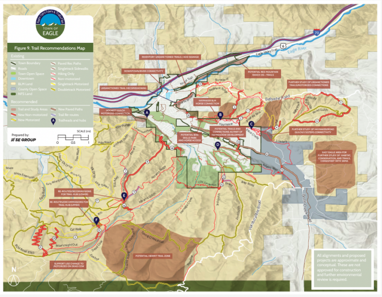
The Hardscrabble Trails Coalition (HTC), in partnership with the VVMTA is proposing 11 miles of reroutes and new trails and reroutes in Town of Eagle Open Space and adjacent lands managed by the Bureau of Land Management (BLM).
These trails are proposed and not approved. All of these proposals are planned to undergo further environmental reviews to understand what impacts they may have. These environmental reviews will occur in the summer of 2025. After the environmental reviews are finished and analyzed, the BLM will release a draft Environmental Assessment in the fall/winter which will provide an opportunity for the public to comment. If approved, the plan is to begin implementation of the plan in 2026
BLM Resource Management Plan
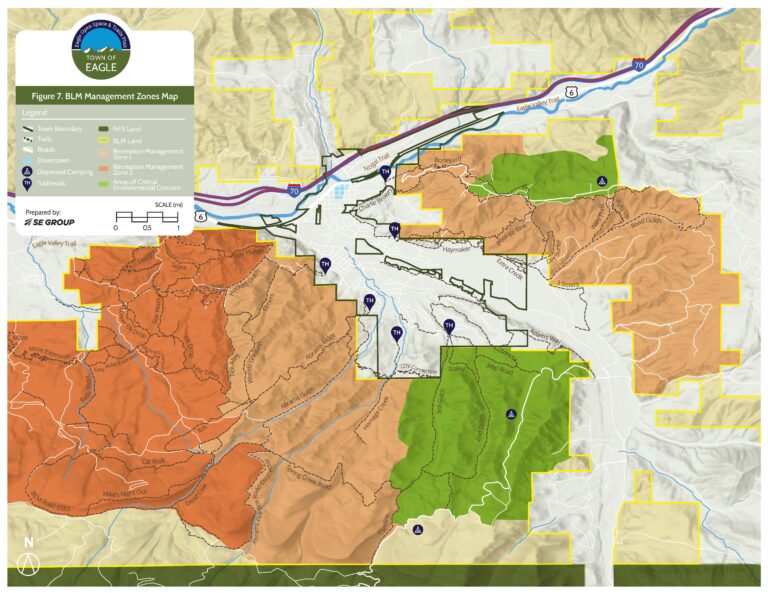
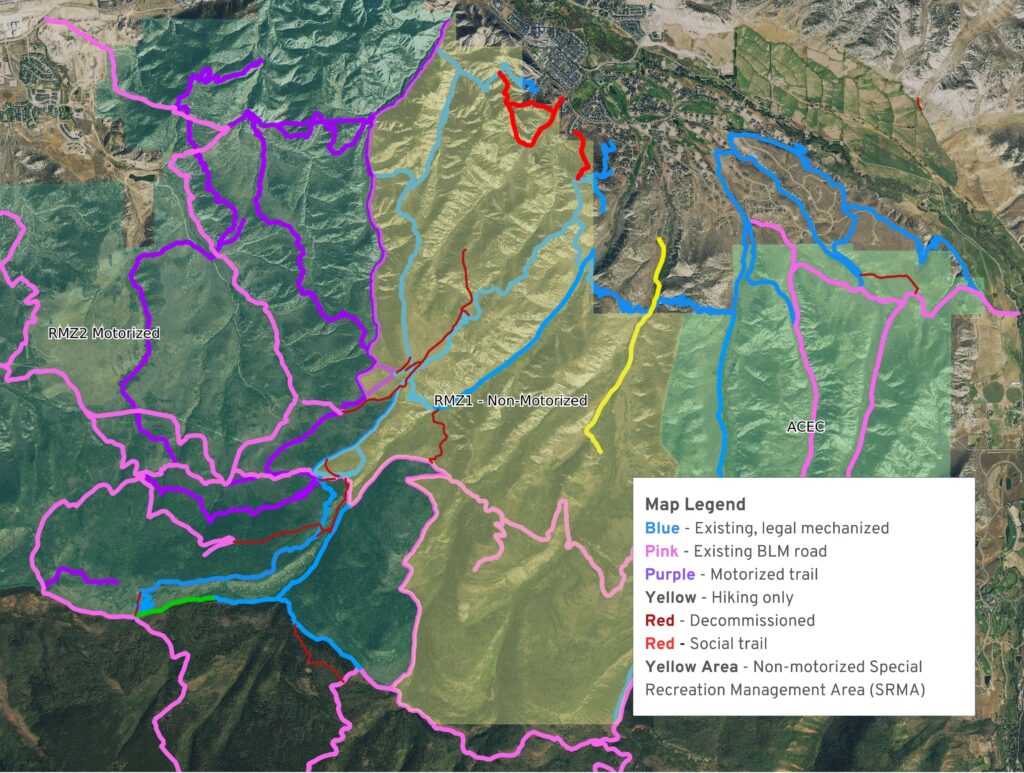
In 2015, the BLM Colorado River Valley Field Office finalized their Resource Management Plan (RMP). This RMP sets the framework for how the BLM manages public lands surrounding Eagle for the next 20+ years. This planning process included significant public input over a three (3) year process. In the end, the RMP established the Hardscrabble-East Eagle Special Recreation Management Area (SRMA). Included in this SRMA designation was the allocation of 12-15 miles of new non-motorized trail in RMZ-1 (see maps below).
Town of Eagle Open Space & Trails Master Plan
The plan being proposed is based on trail concepts approved in the Town of Eagle Open Space and Trails Master Plan. The public engagement process for the Town of Eagle’s Open Space and Trails Master Plan was extensive, inclusive, and guided by a desire to balance recreation and conservation. It included a roundtable meeting with key stakeholders (such as Colorado Parks & Wildlife, Bureau of Land Management, Eagle Valley Land Trust, Eagle County, Vail Valley Mountain Trails Alliance, Hardscrabble Trails Coalition, Mountain Trekkers and others), a community visioning open house attended by 50–60 people, and an online survey with 234 responses. Input was also gathered through focus groups on open space and trails, targeted outreach with community organizations, and multiple public meetings during draft review.
These efforts highlighted the community’s strong values around trail connectivity, open space preservation, maintaining existing infrastructure and wildlife conservation. The public supported new trails focused on improving the trail system opportunities and connections, while expressing concerns about impacts to wildlife and a desire for responsible recreation planning. In finalizing the concepts, additional input from the Town of Eagle, CPW, BLM and user groups (trail runners, hikers, bicyclists, motorized, equestrian users) was solicited and incorporated into the plan.
Eagle Trail Improvements - Phase #1
In 2024, the VVMTA and HTC celebrated a monumental achievement with the completion of Phase 1 of Eagle trail projects. This collaborative endeavor supported by the Town of Eagle and the BLM has significantly enhanced the trail network in the Eagle area, focusing on strategic reroutes, the development of trail hubs, improved navigation, and the decommissioning of unsustainable trails. The projects addressed critical objectives such as rerouting eroding trails, managing unsanctioned trails, performing trail maintenance, and implementing habitat improvement projects. These enhancements not only improve trail sustainability but also elevate the overall experience for all users. Phase 1 laid a robust foundation for this proposed Phase #2 of trail improvements in the Eagle area.
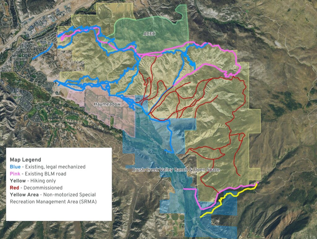
In the end, Phase #1 included decommissioning 15.63 miles of unauthorized trails, reroutes and improvements of over 5 miles of existing trail, and rehabilitating 3.85 miles of social trails.
Phase #2 Project Goals
- A sustainable trail system to meet the needs of the community for the next 20+ years.
- Balance recreation, wildlife and natural resources by placing trail concepts in areas with existing recreational impact.
- Ecological improvements to the Hernage Creek and Abrams Creek watersheds.
- Maintain open blocks of land to minimize fragmented habitat.
- Maximize new trail experiences with limited new mileage.
- Improve existing trails to provide better access to West Eagle.
- Provide different types of trail experiences for all users and abilities.
- Limit trail expansion in East Eagle beyond Road Gulch to preserve wildlife migration corridors.
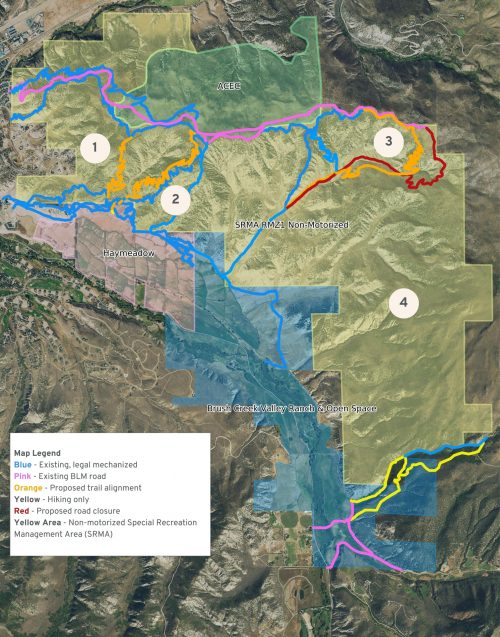
East Eagle Trails Proposal
1 – Redneck Alternate Downhill 1.25 Miles
Proposed with the downhill experience in mind. Intermediate to advanced to allow progression from existing area trails. Natural and built features used to create a new, challenging experience.
2 – Haymaker Uphill 1.75 Miles
Proposed with the uphill experience in mind. Provides direct beginner-intermediate access from Haymeadow to support growth. Alleviates pressure from Boneyard Trail.
3 – Hillbilly Extension 1.85 Miles
Adds longer loop options while keeping trail inside existing impact zone of RoadGulch. Intermediate/Advanced, technical rocky experience.
4 – Wildlife Habitat & Migration Corridor
Large area of habitat left open for migration corridors, support conservation goals of Brush Creek Valley Ranch and Open Space owned by Eagle County and Colorado Parks and Wildlife.
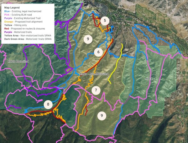
West Eagle Trails Proposal
5 – School House Connector 1.25 Miles
Multi-use, multi directional trail built to provide connections to downtown and existing public parking, close hiking/dog walking loop. No public connectors to Seabury Street or Newquist Street. Public access will be from School House Rock and Kill Bill.
6 – Abrams Gulch Reroute
By re-routing Abrams Gulch we can improve and provide desired, easier area access without a new trail.
7 – Hermit Trails 3.76 Miles
Epic backcountry, technical trail. Outside of Hernage Creek watershed and within existing impacted area.
8 – Deadcow & Firebox Reroutes
Re-routes provide motorized & non-motorized access supported by Rocky Mountain Sports Riders, watershed improvements, significantly better access to Mike’s Night Out and Hermit Trail with limited new impact.
9 – Additional Considerations
Large areas of no new trails for habitat.
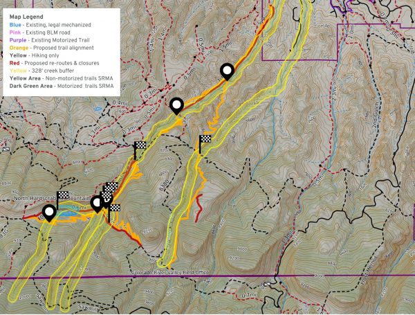
West Eagle Watershed Improvements
- Existing trail alignments include:
- 3.5 miles inside the recommended creek buffer of 328′
- 6 existing creek crossings without bridges
- 2 large wetland areas
- New trail alignments
- Remove over 3.25 miles of trail from inside the recommended creek buffer of 328′
- Reduction of creek crossings from 6 to 3
- Build bridges for all 3 creek crossings
- Moves the trails outside the wetland areas
Final Thoughts
We couldn’t be more excited about this trails proposal. It reflects years of thoughtful planning, meaningful community engagement, and a deep commitment to balancing outdoor recreation with conservation. Every step was guided by a vision to improve access, provide new and unique trail experiences, protect wildlife habitat, and strengthen Eagle’s identity as a vibrant, outdoor-centered community. This project will preserve what makes Eagle special for generations to come.
If you have any questions please reach out to us at info@vvmta.org or Laura@hardscrabbletrailscoalition.org.

